
One thing is for sure, looking at the world through the eyes of a satellite gives us an opportunity to discover new land. Especially new in the sense of not known personally about it before. Parts of the joy in these discoveries is to look closer into an area, find out more about the place, simply from geographical coordinates and searching the Internet.
Amazonas for example. By first searching Sentinel Hub for Amazonas in Brazil, I came across Piauí, which according to Wikipedia is one of the states of Brazil, located in the country’s Northeast Region. Within the state of Piauí, I found a small municipality called Regeneração.

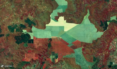


Looking at the place in different color bands, predefined by the satellite viewer tool, I could see how the fields differ from each other. Why is that? Different crops?
A message for satellite eyes
The Sentinel Hub satellite viewer doesn’t give me that high resolution imagery, so I tried search for the place in Bing Maps. They had a set of images which they have paid for and has far better resolution of the same place. Remember I used the geographical coordinates to find the place. Then I discovered something more, they have written a text in the fields using trees or something alike. How clever and amusing isn’t that. It sure amused me.


Thanks to Sentinel Hub and Bing Maps for making this post worth writing.